Emerald Isle's Changing Sands
Jun/25/10 04:42 PM
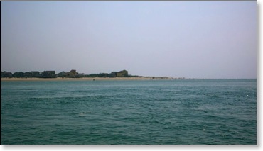
A vacation along the Crystal Coast is often remarkable for what has not changed. Year after year the waters are still emerald colored and as clear as crystal.
No matter when you come, there is still plenty of room on the beach, and the fresh local seafood always tastes great.
While the Crystal Coast portion of the Southern Outer Banks has far more dense vegetation than many strands of sand, still along the shores and at the ends of the beaches, water and wind can make some substantial changes in a short period of time.
When I was a teenager back in the sixties, I first visited the Point at Emerald Isle with my Uncle Austin. We had to take my old four wheel drive Bronco a few miles down the undeveloped beach just to get there.
In 2007 I bought my first beach driving permit from the town of Emerald Isle. I wanted to go fishing once again on the Point. Within a week the access to the Point was closed and the Point had practically disappeared at least at high tide. Over the past few years things have definitely changed again.
If you walked the beaches to the east of the Point in the last couple of years, it was pretty easy to notice the wide expanse of sand building in the area. These beaches have become very impressive and perhaps some of the best on North Carolina's coast.
By December 2008, a build-up of sand brought the Point back above the water even at high tide. The access was repaired and things started looking more normal. Last summer the sand continued to grow along the edges. To the east a shallow arm of water had formed. It turned out to be a favorite spot for small and big children.
Unfortunately further accumulations of sand cut the water off from the ocean, and it needed to be filled in with sand from dredging. Still the Inlet seemed pretty stable last summer. We had a great time fishing in it and enjoying the boat accessible beaches.
I have walked on the Point a few times during the last year, and while I knew the sand was continuing its progress toward the Inlet, I did not realize the extent of the growth of the Point until we made our first boat trip out in May. Another trip or two has confirmed that the next challenge is not keeping the Point above water but making sure Bogue Inlet stays open for boat traffic.
When you are riding out Bogue Inlet's channel, and you can see people walking not far from the boat channel, you know things have changed massively. From the number of people we can see enjoying the new sands of the Point, it is clear that Mother Nature's changes are very popular with visitors and long term residents.
As a boater and fisherman I have not decided yet. The sands of the Inlet change every year. Last year we found some great structure and had a lot of fun fishing in the Inlet. So far this year, we are still looking for those magic places. Winds and hot weather have limited our explorations so I remain hopeful that the fish will show up, and we will soon figure out the new topography of Bogue Inlet.
One thing that I know for sure is that about the time I have it all figured out, it will change once again either from a storm or just normal winds and currents. That change is just part of life along the Crystal Coast.
Links to more pictures and information about the Point can be found in this article, Big changes at the Point.