


Not much fun on the White Oak
Mar/05/08 21:59 Filed in: Weather
Among other things Alex is a fantastically skilled boater, having practically grown up in boat.
That means I will venture out in the boat with Alex when I would probably leave it on the lift if the job of captain was in my lap.
Monday March 3 we decided to down the White Oak to Swansboro and then over towards Hammocks Beach State Park where rumor had it there might be some fish.
We left on a falling tide, knowing we didn't have a lot of time. Usually the trip to Swansboro is pretty uneventful if you just follow the channel markers.
Fortunately I have a GPS in our boat and took the time last summer to mark all the buoys.
I say that because there are a couple of markers missing as you get to Swansboro.
There is buoy missing before the island and the last marker after the island as you turn to go towards the bridge is also gone.
If you have boated on the White Oak, you know that having missing channel markers on a falling tide is the last thing you want next to fog or darkness.
We managed okay, but by the time we got down to the Hammocks Beach area, the supposed fishing hole was a dry spot so we turned around and headed home.
One of the great disadvantages to visiting our area on a short trip is that you end up forcing what you do into a tiny window.
That being said we took off in the boat the next morning. We did that knowing that there were winds of ten to fifteen miles per hour. We also knew that sometimes the White Oak can be choppier than the sounds.
As we were riding by the dock of a neighbor, he told us to be careful up by Swansboro since some buoys were missing. We thanked him for the warning even if it was a day late.
Even with some wind we were hoping to make it up to Stella and perhaps fish for a few minutes in the White Oak after it narrows. Unfortunately the farther up river we got, the worse the waves became.
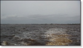
Just as we were close to making our last turn up the river by the campground, the waves were at two to three feet. I was too busy then to take photographs.
We made the decision that we should make a run for home before things got any worse.
Of course by the time we got back to Hancock Point and Bluewater Cove, the waves dropped substantially.
The picture at the top is after we got back to the markers in mid-river.
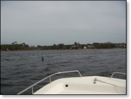
This picture at Green 15 is just as you see Worthy of the Lamb before getting to the Bluewater Cove channel at Red 16.
Of course the closer we got to home the quieter it got.
As the kids were packing to leave the next morning, there seemed to be an extra foot or so of water behind the house, the sky was blue and the winds were calm.
Oh well, there is always next time.